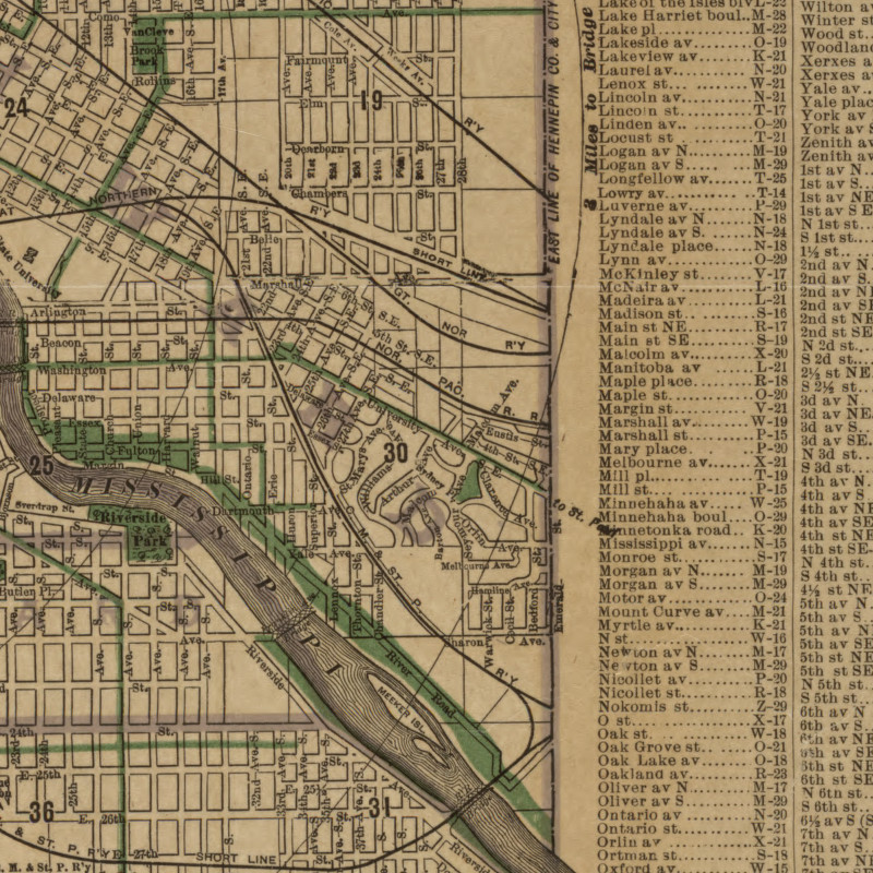
Powderhorn Lake
Amelia Lake
Rice Lake
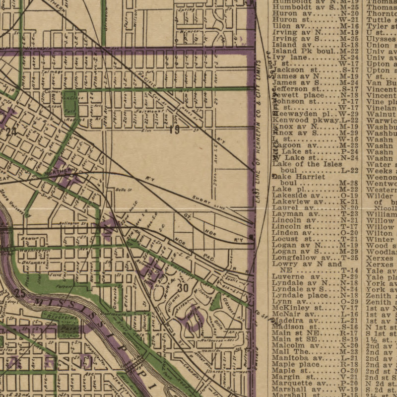
Cedar Lake
Lake of the Isles Lake
Sandy Lake
Pearl Lake
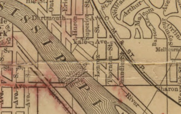
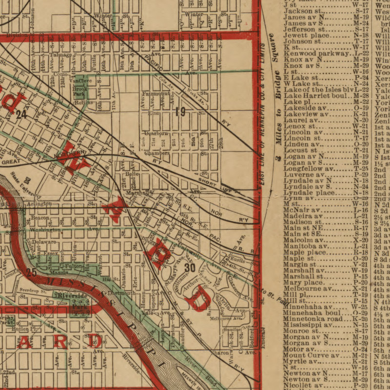
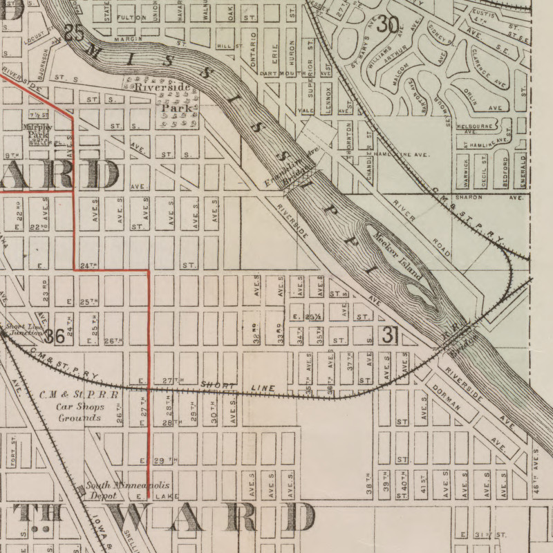
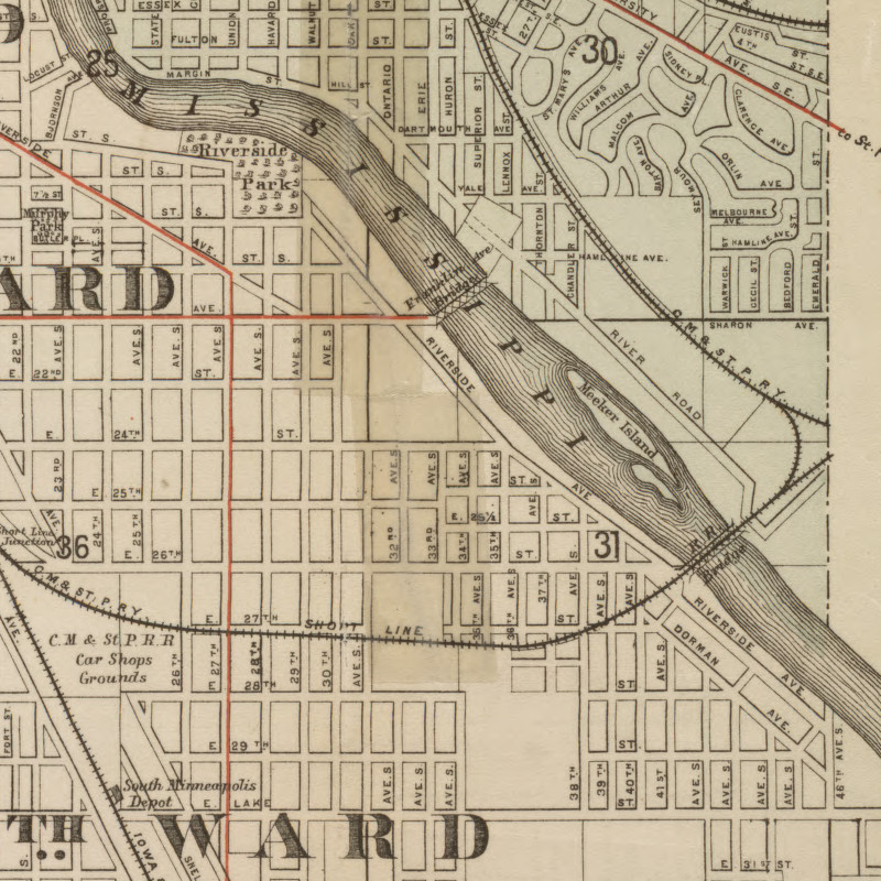
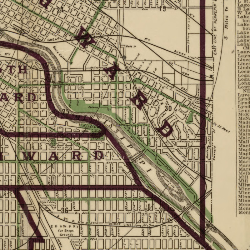
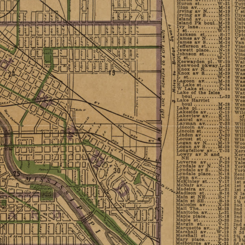
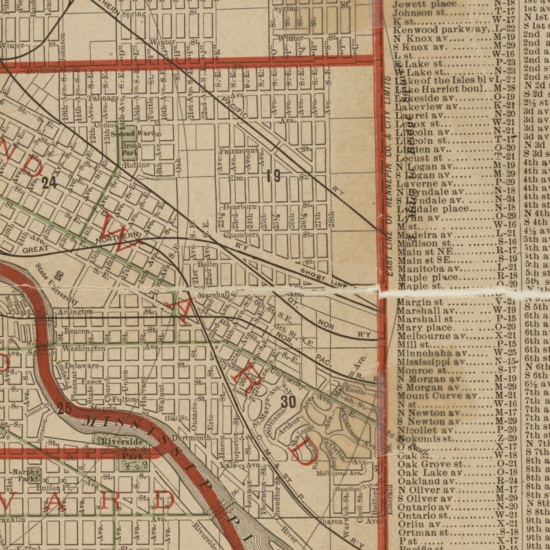
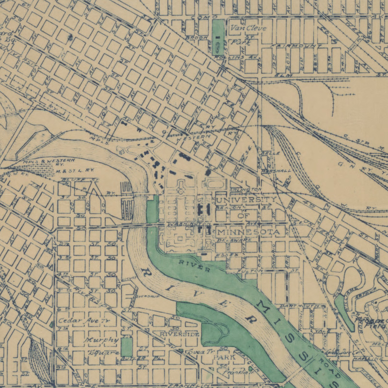
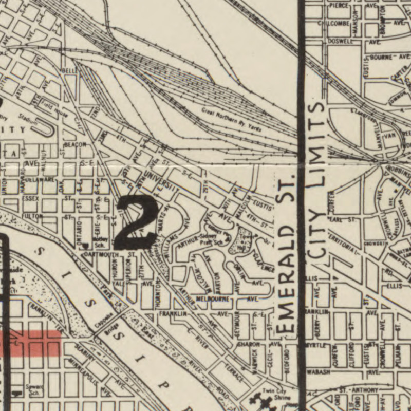
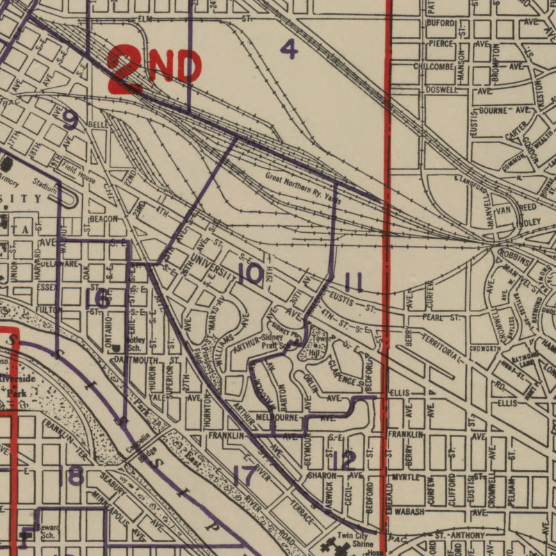
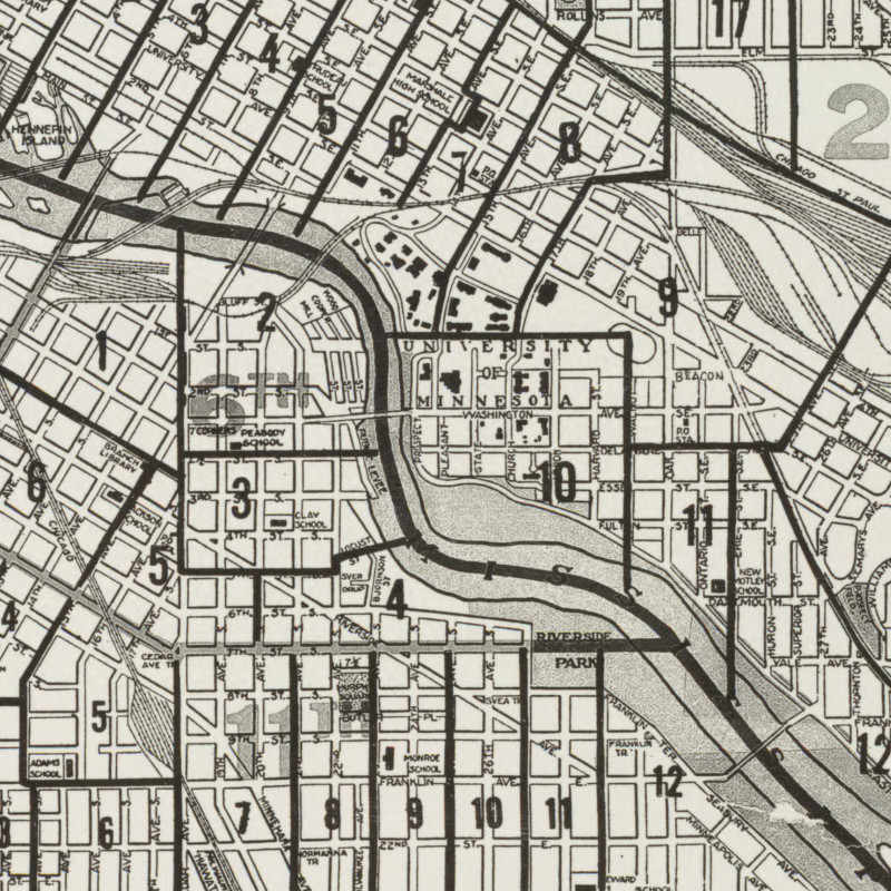
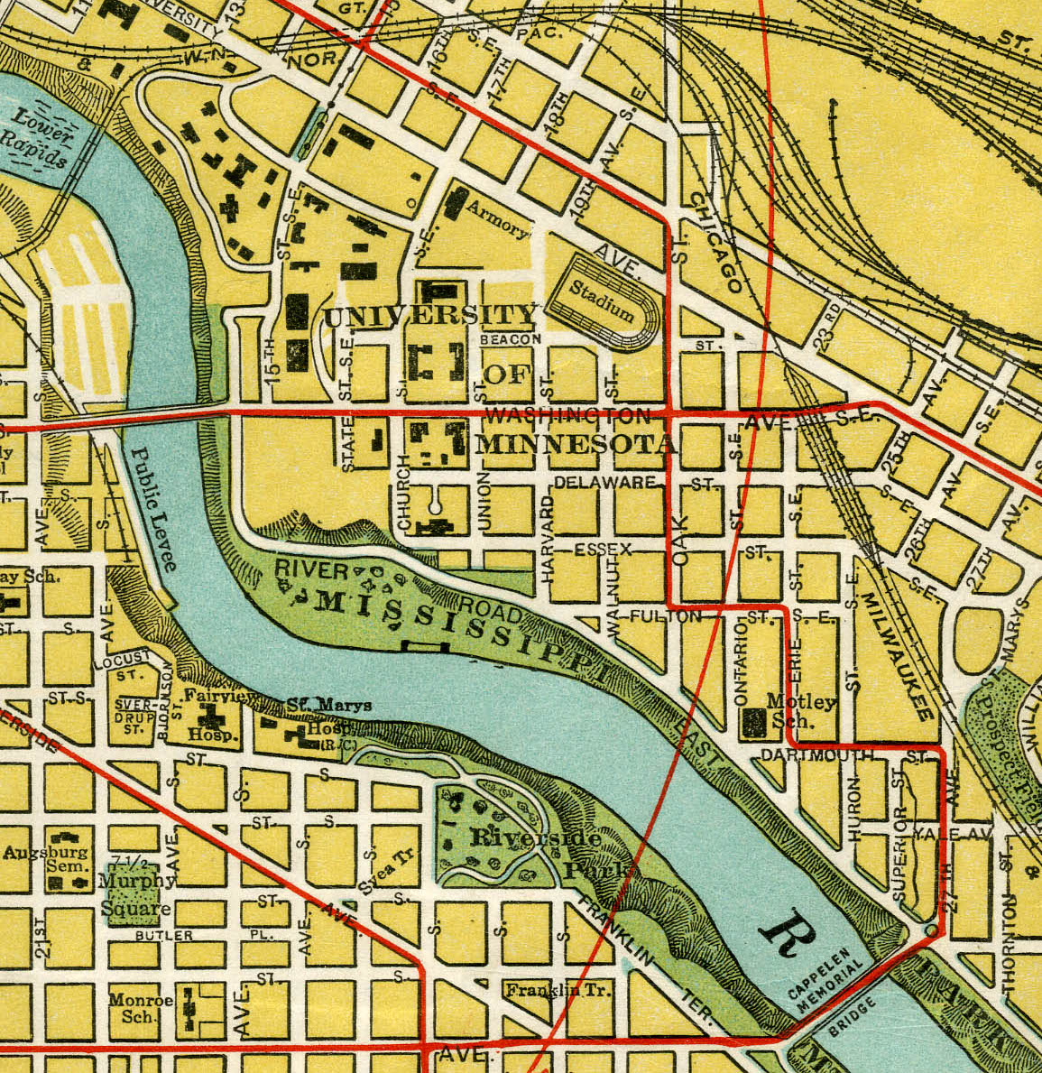
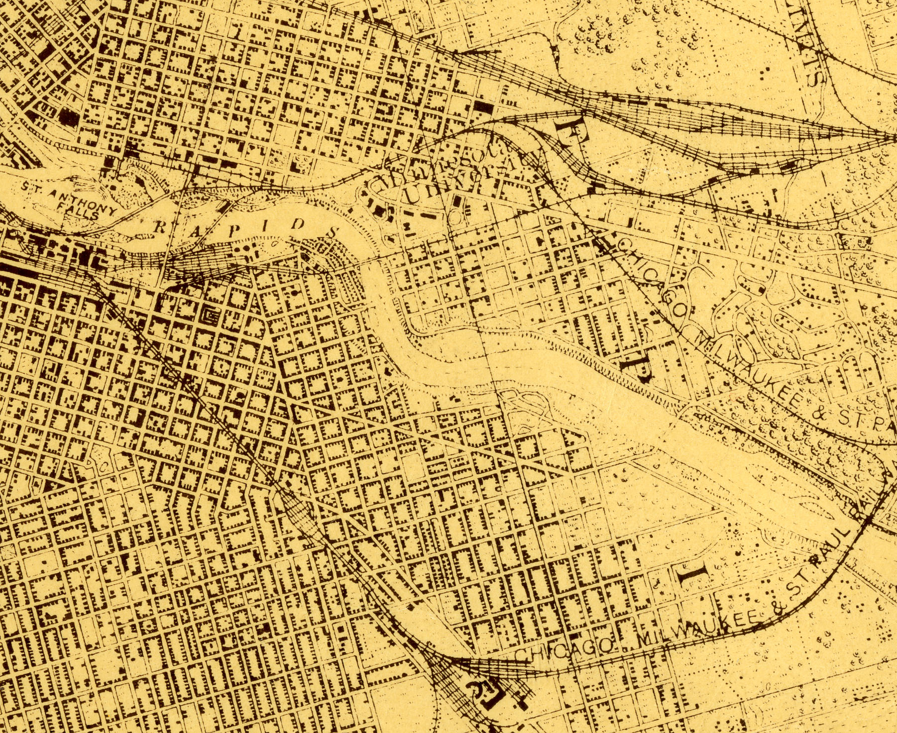
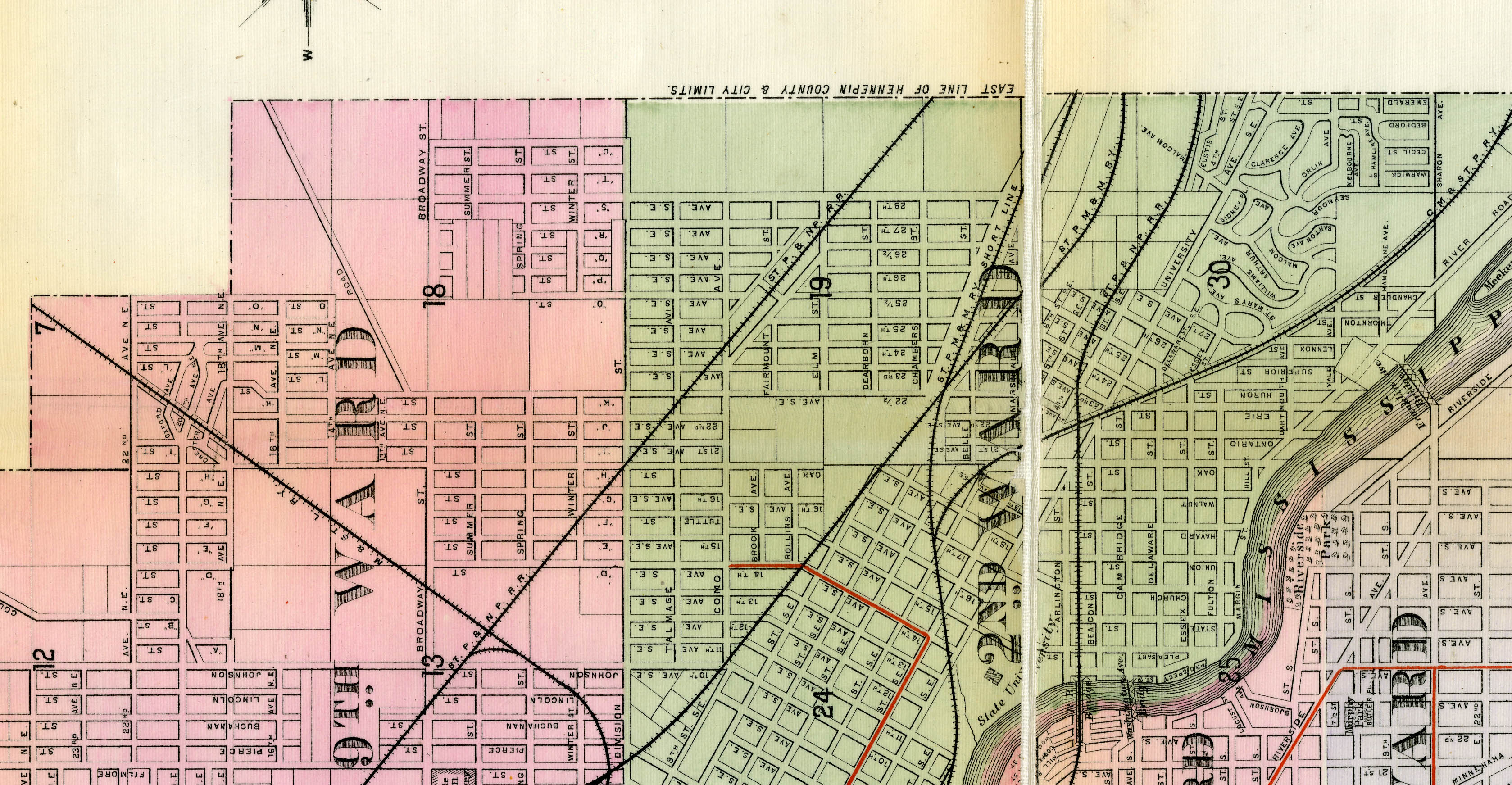
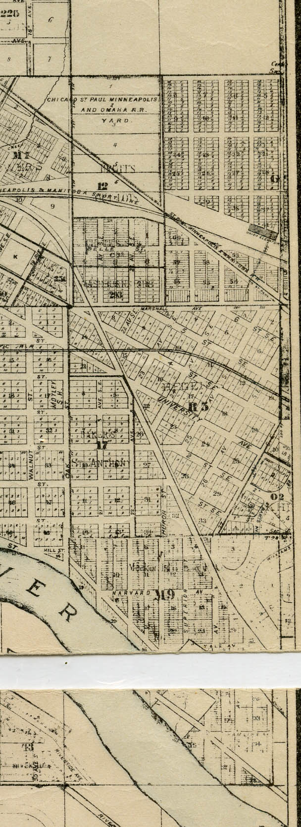
Mississippi River
Minnehaha Creek
Nicollet Island
| |
| Link | http://reflections.mndigital.org/u?/mpls,324 |
| Title | Map of the City of Minneapolis, Minn. 1894. |
| Creator | Manz, J. and Company |
| Contributor | Cooper, W. P. |
| Description | Political map of the city of Minneapolis. |
| Date of Creation | 1894 |
| Publishing Agency | Minneapolis Directory Company |
| Dimensions | 56.5 x 39 |
| Physical Format | paper |
| General Subject | Politics and government |
| Geographic Feature | Harriet Lake Powderhorn Lake Amelia Lake Rice Lake Cedar Lake Lake of the Isles Lake Sandy Lake Pearl Lake Mississippi River Minnehaha Creek Nicollet Island |
| Geographic Township | 28; 29 |
| Geographic Range | 21; 24 |
| Litoral | w |
| Principal Meridian | 4th |
| Minnesota City/Township | Minneapolis |
| Minnesota County | Hennepin |
| State | Minnesota |
| Country | United States |
| Contributing Institution | Hennepin County Library, James K. Hosmer Special Collections Library, 300 Nicollet Mall, Minneapolis, MN 55401; http://www.hclib.org |
| Rights Management | This image may not be reproduced for any reason without the express written consent of the Hennepin County Library. |
| Local Identifier | 34 |
| MDL Identifier | umn18772 |
| OCLC number | 502262477 |
 | |
| Link | http://reflections.mndigital.org/u?/mpls,321 |
| Title | Map of the City of Minneapolis |
| Creator | Manz, J. and Company |
| Description | Political map of the city of Minneapolis with street and avenue guide. |
| Date of Creation | 1898 |
| Publishing Agency | Minneapolis Directory Company |
| Dimensions | 64 x 47 |
| Physical Format | Paper |
| General Subject | Politics and government |
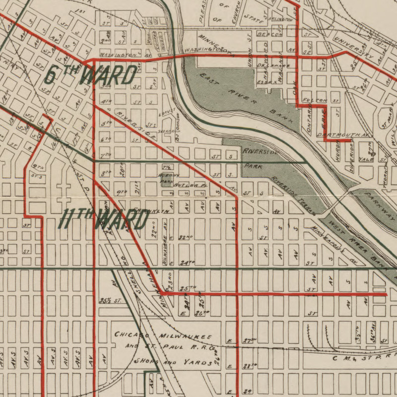
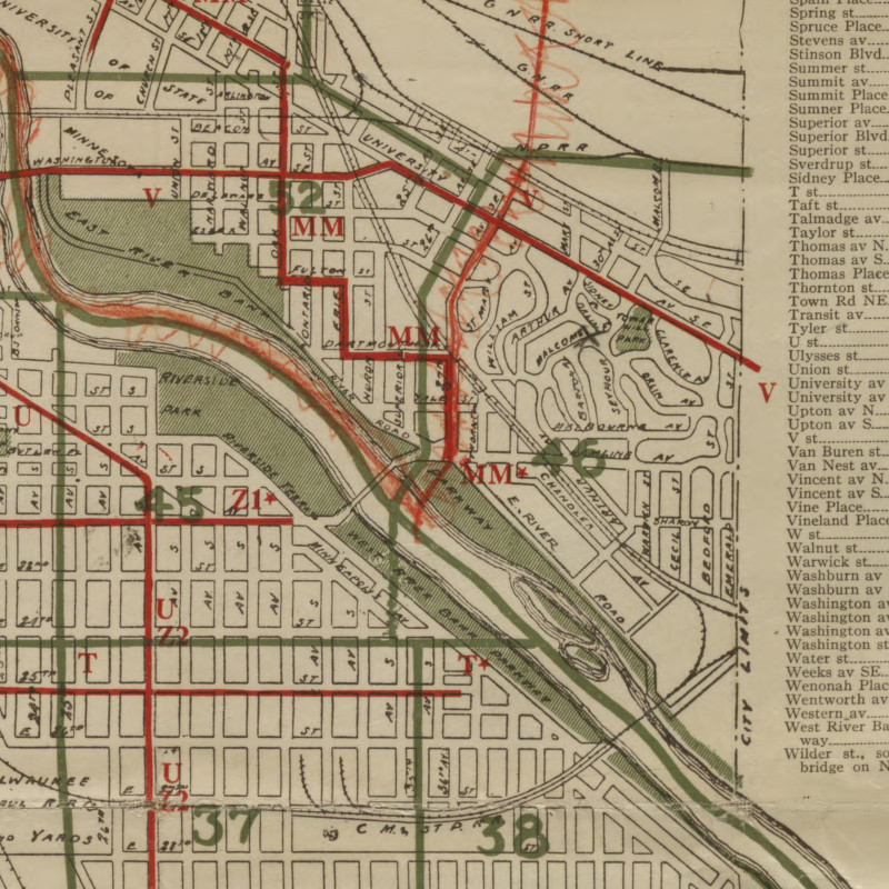
| Local Subject | Minneapolis wards; |
| Geographic Feature | Harriet Lake Powderhorn Lake Amelia Lake Rice Lake Cedar Lake Lake of the Isles Lake Sandy Lake Mississippi River Minnehaha Creek Nicollet Island |
| Geographic Township | 28; 29 |
| Geographic Range | 21; 24 |
| Litoral | w |
| Principal Meridian | 4th |
| Minnesota City/Township | Minneapolis |
| Minnesota County | Hennepin |
| State | Minnesota |
| Country | United States |
| Contributing Institution | Hennepin County Library, James K. Hosmer Special Collections Library, 300 Nicollet Mall, Minneapolis, MN 55401; http://www.hclib.org |
| Rights Management | This image may not be reproduced for any reason without the express written consent of the Hennepin County Library. |
| Local Identifier | 9 |
| MDL Identifier | umn18769 |
| OCLC number | 502262472 |
 | |
| Link | http://reflections.mndigital.org/u?/mpls,308 |
| Title | Map of the City of Minneapolis |
| Creator | Higbee, E.F. |
| Description | Political map of the city of Minneapolis with railways. |
| Date of Creation | 1889 |
| Publishing Agency | Minneapolis Directory Company |
| Dimensions | 77 x 50.5 |
| Physical Format | Canvas |
| General Subject | Politics and government |
| Local Subject | Minneapolis wards |
| Geographic Feature | Harriet Lake Calhoun Lake Powderhorn Lake Amelia Lake Rice Lake Cedar Lake Lake of the Isles Lake Sandy Lake Mississippi River Minnehaha Creek Nicollet Island |
| Geographic Township | 28; 29 |
| Geographic Range | 21; 24 |
| Litoral | w |
| Principal Meridian | 4th |
| Minnesota City/Township | Minneapolis |
| State | Minnesota |
| Country | United States |
| Contributing Institution | Hennepin County Library, James K. Hosmer Special Collections Library, 300 Nicollet Mall, Minneapolis, MN 55401; http://www.hclib.org |
| Rights Management | This image may not be reproduced for any reason without the express written consent of the Hennepin County Library. |
| Local Identifier | 28 |
| MDL Identifier | umn18783 |
| OCLC number | 502262440 |
 | |
| Link | http://reflections.mndigital.org/u?/mpls,312 |
| Title | Map of the City of Minneapolis. |
| Creator | Higbee, E. F. |
| Description | Political map of the city of Minneapolis. |
| Date of Creation | 1890 |
| Publishing Agency | Minneapolis Directory Company |
| Dimensions | 81.5 x 52 |
| Physical Format | paper |
| General Subject | Politics and government |
| Local Subject | Minneapolis wards; |
| Geographic Feature | Harriet Lake Calhoun Lake Powderhorn Lake Amelia Lake Rice Lake Cedar Lake Lake of the Isles Lake Sandy Lake Mississippi River Minnehaha Creek Nicollet Island |
| Geographic Township | 28; 29 |
| Geographic Range | 21; 24 |
| Litoral | w |
| Principal Meridian | 4th |
| Minnesota City/Township | Minneapolis |
| Minnesota County | Hennepin |
| State | Minnesota |
| Country | United States |
| Contributing Institution | Hennepin County Library, James K. Hosmer Special Collections Library, 300 Nicollet Mall, Minneapolis, MN 55401; http://www.hclib.org |
| Rights Management | This image may not be reproduced for any reason without the express written consent of the Hennepin County Library. |
| Local Identifier | 10 |
| MDL Identifier | umn18786 |
| OCLC number | 502259782 |
 | |
| Link | http://reflections.mndigital.org/u?/mpls,305 |
| Title | Map of the City of Minneapolis, Minn. |
| Creator | Benneche, H.W. |
| Description | Political map of the city of Minneapolis with street and avenue guide. |
| Date of Creation | 1922 |
| Publishing Agency | Minneapolis Directory Company |
| Dimensions | 59 x 43.5 |
| Physical Format | paper |
| General Subject | Politics and government |
| Local Subject | Minneapolis wards; |
| Geographic Feature | Harriet Lake Calhoun Lake Powderhorn Lake Nokomis Lake Rice Lake Cedar Lake Lake of the Isles Lake Glenwood Lake Brownie Lake Mississippi River Minnehaha Creek Nicollet Island |
| Geographic Township | 28; 29 |
| Geographic Range | 21; 24 |
| Litoral | w |
| Principal Meridian | 4th |
| Minnesota City/Township | Minneapolis |
| Minnesota County | Hennepin |
| State | Minnesota |
| Country | United States |
| Contributing Institution | Hennepin County Library, James K. Hosmer Special Collections Library, 300 Nicollet Mall, Minneapolis, MN 55401; http://www.hclib.org |
| Rights Management | This image may not be reproduced for any reason without the express written consent of the Hennepin County Library. |
| Local Identifier | 111 |
| MDL Identifier | umn18777 |
| OCLC number | 502262432 |
 | |
| Link | http://reflections.mndigital.org/u?/mpls,302 |
| Title | Map of the City of Minneapolis |
| Creator | Benneche, H.W. |
| Description | Political map of the city of Minneapolis with street and avenue guide. |
| Date of Creation | 1919 |
| Publishing Agency | Minneapolis Directory Company |
| Dimensions | 59 x 43.5 |
| Physical Format | paper |
| General Subject | Politics and government |
| Local Subject | Minneapolis wards; |
| Geographic Feature | Harriet Lake Calhoun Lake Powderhorn Lake Nokomis Lake Rice Lake Cedar Lake Lake of the Isles Lake Glenwood Lake Brownie Lake Mississippi River Minnehaha Creek Nicollet Island |
| Geographic Township | 28; 29 |
| Geographic Range | 21; 24 |
| Litoral | w |
| Principal Meridian | 4th |
| Minnesota City/Township | Minneapolis |
| Minnesota County | Hennepin |
| State | Minnesota |
| Country | United States |
| Contributing Institution | Hennepin County Library, James K. Hosmer Special Collections Library, 300 Nicollet Mall, Minneapolis, MN 55401; http://www.hclib.org |
| Rights Management | This image may not be reproduced for any reason without the express written consent of the Hennepin County Library. |
| Local Identifier | 42 |
| MDL Identifier | umn18774 |
| OCLC number | 502262420 |
 | |
| Link | http://reflections.mndigital.org/u?/mpls,301 |
| Title | Map of the City of Minneapolis |
| Creator | Manz, J. and Company |
| Description | Political map of the city of Minneapolis with street and avenue guide. |
| Date of Creation | 1893 |
| Publishing Agency | Minneapolis Directory Company |
| Dimensions | 59 x 43 |
| Physical Format | paper |
| General Subject | Politics and government |
| Local Subject | Minneapolis wards; |
| Geographic Feature | Harriet Lake Calhoun Lake Powderhorn Lake Amelia Lake Rice Lake Cedar Lake Lake of the Isles Lake Glenwood Lake Sandy Lake Mississippi River Minnehaha Creek Nicollet Island |
| Geographic Township | 28; 29 |
| Geographic Range | 21; 24 |
| Litoral | w |
| Principal Meridian | 4th |
| Minnesota City/Township | Minneapolis |
| Minnesota County | Hennepin |
| State | Minnesota |
| Country | United States |
| Contributing Institution | Hennepin County Library, James K. Hosmer Special Collections Library, 300 Nicollet Mall, Minneapolis, MN 55401; http://www.hclib.org |
| Rights Management | This image may not be reproduced for any reason without the express written consent of the Hennepin County Library. |
| Local Identifier | 3 |
| MDL Identifier | umn18773 |
| OCLC number | 502262418 |
 | |
| Link | http://reflections.mndigital.org/u?/mpls,297 |
| Title | Map of the City of Minneapolis |
| Creator | Manz, J. and Company |
| Description | Political map of the city of Minneapolis with street and avenue guide. |
| Date of Creation | 1912 |
| Publishing Agency | Minneapolis Directory Company |
| Dimensions | 63.5 x 47.5 |
| Physical Format | paper |
| General Subject | Politics and government |
| Local Subject | Minneapolis wards; |
| Geographic Feature | Harriet Lake Calhoun Lake Powderhorn Lake Amelia Lake Rice Lake Cedar Lake Lake of the Isles Lake Sandy Lake Mississippi River Minnehaha Creek Nicollet Island |
| Geographic Township | 28; 29 |
| Geographic Range | 21; 24 |
| Litoral | w |
| Principal Meridian | 4th |
| Minnesota City/Township | Minneapolis |
| Minnesota County | Hennepin |
| State | Minnesota |
| Country | United States |
| Contributing Institution | Hennepin County Library, James K. Hosmer Special Collections Library, 300 Nicollet Mall, Minneapolis, MN 55401; http://www.hclib.org |
| Rights Management | This image may not be reproduced for any reason without the express written consent of the Hennepin County Library. |
| Local Identifier | 44 |
| MDL Identifier | umn18767 |
| OCLC number | 502259977 |
 | |
| Link | http://reflections.mndigital.org/u?/mpls,287 |
| Title | City of Minneapolis |
| Creator | Yarwood, F.W. |
| Description | Political map of the city of Minneapolis with a street and avenue guide. |
| Date of Creation | 1913 |
| Publishing Agency | Yarwood, F.W. |
| Dimensions | 82 x 56 |
| Physical Format | paper |
| General Subject | Politics and government |
| Local Subject | Minneapolis wards; Minneapolis parks; |
| Geographic Feature | Harriet Lake Calhoun Lake Powderhorn Lake Nokomis Lake Rice Lake Diamond Lake Pearl Lake Cedar Lake Lake of the Isles Lake Glenwood Lake Brownie Lake Silver Lake Crystal Lake Mississippi River Minnehaha Creek |
| Geographic Township | 28; 29 |
| Geographic Range | 21; 24 |
| Litoral | w |
| Principal Meridian | 4th |
| Minnesota City/Township | Minneapolis |
| Minnesota County | Hennepin |
| State | Minnesota |
| Country | United States |
| Contributing Institution | Hennepin County Library, James K. Hosmer Special Collections Library, 300 Nicollet Mall, Minneapolis, MN 55401; http://www.hclib.org |
| Rights Management | This image may not be reproduced for any reason without the express written consent of the Hennepin County Library. |
| Local Identifier | 58 |
| MDL Identifier | umn18787 |
| OCLC number | 502262681 |
 | |
| Link | http://reflections.mndigital.org/u?/mpls,284 |
| Title | City of Minneapolis |
| Creator | Benneche, H.W. |
| Description | Map of the city of Minneapolis showing streetcar lines; includes street and avenue guide. |
| Date of Creation | 1919 |
| Publishing Agency | First & Security National Bank |
| Dimensions | 78.5 x 51.5 |
| Physical Format | Canvas |
| General Subject | Transportation |
| Local Subject | Streetcar lines; |
| Geographic Feature | Harriet Lake Calhoun Lake Powderhorn Lake Rice Lake Nokomis Lake Lake of the Isles Lake Cedar Lake Sandy Lake Mississippi River Minnehaha Creek Nicollet Island |
| Geographic Township | 28; 29 |
| Geographic Range | 21; 24 |
| Litoral | w |
| Principal Meridian | 4th |
| Minnesota City/Township | Minneapolis |
| Minnesota County | Hennepin |
| State | Minnesota |
| Country | United States |
| Contributing Institution | Hennepin County Library, James K. Hosmer Special Collections Library, 300 Nicollet Mall, Minneapolis, MN 55401; http://www.hclib.org |
| Rights Management | This image may not be reproduced for any reason without the express written consent of the Hennepin County Library. |
| Local Identifier | 63 |
| MDL Identifier | umn18754 |
| OCLC number | 502262675 |
 | |
| Link | http://reflections.mndigital.org/u?/mpls,286 |
| Title | Map of the City of Minneapolis, Minn. |
| Creator | Benneche, H.W. |
| Description | Map of the city of Minneapolis showing city wards; includes street and avenue guide. |
| Date of Creation | 1917 |
| Publishing Agency | Minneapolis Directory Company |
| Dimensions | 63.5 x 48 |
| Physical Format | paper |
| General Subject | Politics and government |
| Local Subject | Minneapolis wards; |
| Geographic Feature | Harriet Lake Calhoun Lake Lake of the Isles Lake Cedar Lake Glenwood Lake Rice Lake Nokomis Lake Mississippi River Minnehaha Creek Nicollet Island Boom Island Hennepin Island |
| Geographic Township | 28; 29 |
| Geographic Range | 21; 24 |
| Litoral | w |
| Principal Meridian | 4th |
| Minnesota City/Township | Minneapolis |
| Minnesota County | Hennepin |
| State | Minnesota |
| Country | United States |
| Contributing Institution | Hennepin County Library, James K. Hosmer Special Collections Library, 300 Nicollet Mall, Minneapolis, MN 55401; http://www.hclib.org |
| Rights Management | This image may not be reproduced for any reason without the express written consent of the Hennepin County Library. |
| Local Identifier | 55 |
| MDL Identifier | umn18755 |
| OCLC number | 502262679 |
 | |
| Link | http://reflections.mndigital.org/u?/mpls,155 |
| Title | Park System City of Minneapolis 1916 |
| Creator | Wirth, Theodore |
| Contributor | Doell, Chas. E. |
| Description | Map of Minneapolis city parks, lakes, and parkways. |
| Date of Creation | 1916 |
| Publishing Agency | Board of Park Commissioners |
| Dimensions | 105 x 68 |
| Physical Format | canvas |
| General Subject | Sports and recreation |
| Local Subject | Minneapolis Park System |
| Geographic Feature | Harriet Lake Calhoun Lake Powderhorn Lake Nokomis Lake Rice Lake Diamond Lake Pearl Lake Cedar Lake Lake of the Isles Lake Glenwood Lake Brownie Lake Silver Lake Crystal Lake Mississippi River Minnehaha Creek |
| Geographic Township | 28; 29 |
| Geographic Range | 21;24 |
| Litoral | w |
| Principal Meridian | 4th |
| Minnesota City/Township | Minneapolis |
| Minnesota County | Hennepin |
| State | Minnesota |
| Country | United States |
| Contributing Institution | Hennepin County Library, James K. Hosmer Special Collections Library, 300 Nicollet Mall, Minneapolis, MN 55401; http://www.hclib.org |
| Rights Management | This image may not be reproduced for any reason without the express written consent of the Hennepin County Library. |
| Local Identifier | 64 |
| MDL Identifier | umn18795 |
| OCLC number | 502259897 |
 | |
| Link | http://reflections.mndigital.org/u?/mpls,1487 |
| Title | Boundaries of the Thirteen Wards in the City of Minneapolis; Appendix E |
| Creator | City Planning Commission, Minneapolis MN |
| Description | Map of the city of Minneapolis showing ward boundaries and fire limits and fire proof zone. |
| Date of Creation | 1951 |
| Publishing Agency | City Planning Commission, Minneapolis MN |
| Dimensions | 46 x 29 |
| Physical Format | Paper |
| General Subject | Politics and government |
| Local Subject | Minneapolis wards; schools; parks |
| Geographic Feature | Mississippi River Nicollet Island Boom Island Hennepin Island Crystal Lake Brownie Lake Cedar Lake Lake of the Isles Lake Calhoun Lake Harriet Lake Diamond Lake Nokomis Lake Powderhorn Lake Hart Lake |
| Geographic Township | 28; 29 |
| Geographic Range | 21; 24 |
| Litoral | w |
| Principal Meridian | 4th |
| Minnesota City/Township | Minneapolis |
| Minnesota County | Hennepin |
| State | Minnesota |
| Country | United States |
| Contributing Institution | Hennepin County Library, James K. Hosmer Special Collections Library, 300 Nicollet Mall, Minneapolis, MN 55401; http://www.hclib.org |
| Rights Management | This image may not be reproduced for any reason without the express written consent of the Hennepin County Library. |
| Local Identifier | 22 |
| MDL Identifier | umn35772 |
| Transcript | APPENDIX E WARD BOUNDARIES |
| OCLC number | 502262603 |
 | |
| Link | http://reflections.mndigital.org/u?/mpls,1485 |
| Title | City of Minneapolis Election Map |
| Creator | Chas. C. Swanson |
| Description | Map of the city of Minneapolis showing election ward and district boundaries. |
| Date of Creation | 1947 |
| Publishing Agency | Hudson Company, Minneapolis MN |
| Dimensions | 85 x 52.5 |
| Physical Format | Paper |
| General Subject | Politics and government |
| Local Subject | Minneapolis schools; parks; boulevards; streets; railroads |
| Geographic Feature | Mississippi River Nicollet Island Boom Island Hennepin Island Crystal Lake Brownie Lake Cedar Lake Lake of the Isles Lake Calhoun Lake Harriet Lake Diamond Lake Nokomis Lake Powderhorn Lake Hart Lake |
| Geographic Township | 28; 29 |
| Geographic Range | 21; 24 |
| Litoral | w |
| Principal Meridian | 4th |
| Minnesota City/Township | Minneapolis |
| Minnesota County | Hennepin |
| State | Minnesota |
| Country | United States |
| Contributing Institution | Hennepin County Library, James K. Hosmer Special Collections Library, 300 Nicollet Mall, Minneapolis, MN 55401; http://www.hclib.org |
| Rights Management | This image may not be reproduced for any reason without the express written consent of the Hennepin County Library. |
| Local Identifier | 20 |
| MDL Identifier | umn35770 |
| OCLC number | 502259919 |
 | |
| Link | http://reflections.mndigital.org/u?/mpls,1484 |
| Title | City of Minneapolis Election Map |
| Creator | Swanson, Chas. C. |
| Description | Map of the city of Minneapolis showing election ward and district boundaries. |
| Date of Creation | 1929 |
| Publishing Agency | Hudson Company, Minneapolis MN |
| Dimensions | 91 x 53.5 |
| Physical Format | Paper |
| General Subject | Politics and government |
| Local Subject | Minneapolis election wards and districts; railroads; parks; |
| Geographic Feature | Mississippi River Nicollet Island Boom Island Hennepin Island Crystal Lake Glenwood Lake Brownie Lake Cedar Lake Lake of the Isles Lake Calhoun Lake Harriet Lake Diamond Lake Pearl Lake Nokomis Lake Rice Lake Powderhorn Lake Hart Lake |
| Geographic Township | 28; 29 |
| Geographic Range | 21; 24 |
| Litoral | w |
| Principal Meridian | 4th |
| Minnesota City/Township | Minneapolis |
| Minnesota County | Hennepin |
| State | Minnesota |
| Country | United States |
| Contributing Institution | Hennepin County Library, James K. Hosmer Special Collections Library, 300 Nicollet Mall, Minneapolis, MN 55401; http://www.hclib.org |
| Rights Management | This image may not be reproduced for any reason without the express written consent of the Hennepin County Library. |
| Local Identifier | 12 |
| MDL Identifier | umn35764 |
| Transcript | CITY OF MINNEAPOLIS ELECTION MAP 1929 |
| OCLC number | 502259914 |
 | |
| Link | http://reflections.mndigital.org/u?/mpls,1460 |
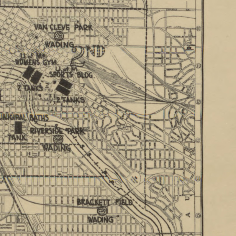
| Title | Map Showing Location and Distribution of Bathing Facilities in the City of Minneapolis |
| Creator | Olson, H. E. |
| Description | Map showing the location of bathing facilities in the city of Minneapolis. |
| Date of Creation | 1935 |
| Publishing Agency | City Planning Commission, City Hall Minneapolis MN |
| Dimensions | 27.5 x 21 |
| Physical Format | Paper |
| General Subject | Sports and recreation |
| Local Subject | Bathing facilities |
| Geographic Feature | Mississippi River Boom Island Nicollet Island Cedar Lake Lake of the Isles Lake Calhoun Lake Harriet Lake Diamond Lake Powderhorn Lake |
| Geographic Township | 28; 29 |
| Geographic Range | 21; 24 |
| Litoral | w |
| Principal Meridian | 4th |
| Minnesota City/Township | Minneapolis |
| Minnesota County | Hennepin |
| State | Minnesota |
| Country | United States |
| Contributing Institution | Hennepin County Library, James K. Hosmer Special Collections Library, 300 Nicollet Mall, Minneapolis, MN 55401; http://www.hclib.org |
| Rights Management | This image may not be reproduced for any reason without the express written consent of the Hennepin County Library. |
| Local Identifier | 15 |
| MDL Identifier | umn35766 |
| Transcript | MAP SHOWING LOCATION & DISTRIBUTION OF BATHING FACILITIES IN THE CITY OF MINNEAPOLIS PREPARED BY CITY PLANNING COMMISSION 339 CITY HALL MPLS. MINN. H.E. OLSON - ENGR. AUGUST 1935 |
| OCLC number | 502259855 |
 | |
| Link | http://reflections.mndigital.org/u?/mpls,1451 |
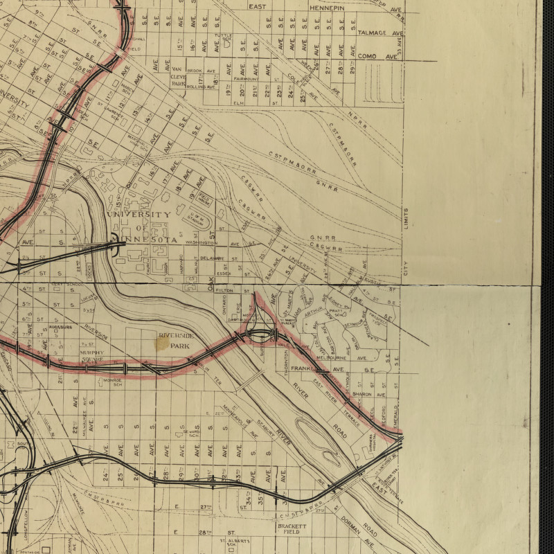
| Title | Line Diagram Map of City of Minneapolis |
| Creator | Minneapolis City Engineers Department |
| Description | Map of the city of Minneapolis showing streets, schools, railroads, and parks. |
| Date of Creation | 1959 |
| Publishing Agency | Minneapolis City Engineers Department |
| Dimensions | 75 x 91.5 |
| Physical Format | Paper |
| General Subject | Transportation |
| Local Subject | Minneapolis schools; parks; boulevards; streets; railroads |
| Geographic Feature | Mississippi River Minnehaha Creek Nicollet Island Boom Island Brownie Lake Cedar Lake Lake of the Isles Lake Calhoun Lake Harriet Lake Diamond Lake Nokomis Lake Powderhorn Lake |
| Geographic Township | 28; 29 |
| Geographic Range | 21; 24 |
| Litoral | w |
| Principal Meridian | 4th |
| Minnesota City/Township | Minneapolis |
| Minnesota County | Hennepin |
| State | Minnesota |
| Country | United States |
| Contributing Institution | Hennepin County Library, James K. Hosmer Special Collections Library, 300 Nicollet Mall, Minneapolis, MN 55401; http://www.hclib.org |
| Rights Management | This image may not be reproduced for any reason without the express written consent of the Hennepin County Library. |
| Local Identifier | 24 |
| MDL Identifier | umn35775 |
| Transcript | LINE DIAGRAM MAP CITY OF MINNEAPOLIS TRAFFIC /DIVISION CITY ENGINEER'S DEPT MINNEAPOLIS MINNESOTA CORRECTED TO JANUARY 1, 1959 |
| OCLC number | 502262493 |
| |
| Link | http://reflections.mndigital.org/u?/mpls,1451 |
| Title | Line Diagram Map of City of Minneapolis |
| Creator | Minneapolis City Engineers Department |
| Description | Map of the city of Minneapolis showing streets, schools, railroads, and parks. |
| Date of Creation | 1959 |
| Publishing Agency | Minneapolis City Engineers Department |
| Dimensions | 75 x 91.5 |
| Physical Format | Paper |
| General Subject | Transportation |
| Local Subject | Minneapolis schools; parks; boulevards; streets; railroads |
| Geographic Feature | Mississippi River Minnehaha Creek Nicollet Island Boom Island Brownie Lake Cedar Lake Lake of the Isles Lake Calhoun Lake Harriet Lake Diamond Lake Nokomis Lake Powderhorn Lake |
| Geographic Township | 28; 29 |
| Geographic Range | 21; 24 |
| Litoral | w |
| Principal Meridian | 4th |
| Minnesota City/Township | Minneapolis |
| Minnesota County | Hennepin |
| State | Minnesota |
| Country | United States |
| Contributing Institution | Hennepin County Library, James K. Hosmer Special Collections Library, 300 Nicollet Mall, Minneapolis, MN 55401; http://www.hclib.org |
| Rights Management | This image may not be reproduced for any reason without the express written consent of the Hennepin County Library. |
| Local Identifier | 24 |
| MDL Identifier | umn35775 |
| Transcript | LINE DIAGRAM MAP CITY OF MINNEAPOLIS TRAFFIC /DIVISION CITY ENGINEER'S DEPT MINNEAPOLIS MINNESOTA CORRECTED TO JANUARY 1, 1959 |
| OCLC number | 502262493 |
 | |
| Information | Unknown |
 | |
| Title | The premier street map of Minneapolis and vicinity |
| Creator | Produced under the direction of Alexander Gross |
| Published | New York, N.Y. : Geographia Map Company, [1954?] |
| Library | University of Minnesota - Twin Cities, Wilson Library |
| Call number | WILS MAPT G 4144.M5 1954.G46X copy 2 |
 | |
| Title | City of Minneapolis |
| Creator | Compiled from the official records in City Engineer’s Office, Board of Park Commissioners and U.S. Topographic Survey by McGill-Warner Company |
| Published | Published St. Paul, Minn. : McGill-Warner Co., c1937. |
| Library | University of Minnesota - Twin Cities, Wilson Library |
| Call number | WILS MAPT G 4144.M5 1937.M34x |
 | |
| Information | Unknown |
| Library | University of Minnesota - Twin Cities, Wilson Library |
| Call number | Found in a stack of uncataloged material. This was one frame of a Mississippi River map following the course of the river through Minneapolis and beyond. |
 | |
| Title | Map of the city of Minneapolis |
| Creator | Higbee, E. F. (Edward F.). |
| Published | Minneapolis City Directory Pub. Co., 1888. |
| Library | University of Minnesota - Twin Cities, Wilson Library |
| Call number | WILS MAPT G 4144.M5 1888.H54x |
 | |
| Information | Unknown |
| Call number | WILS MAPT G 4144.M5 (1887) |
| Notes | [Map no longer appears in the lib.umn.edu online records. I am not sure if they still have the map.] |
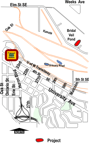 | |
| Source | From City of Minneapolis website on "Cleanup activities related to the Valentine Clarke Superfund Site" |
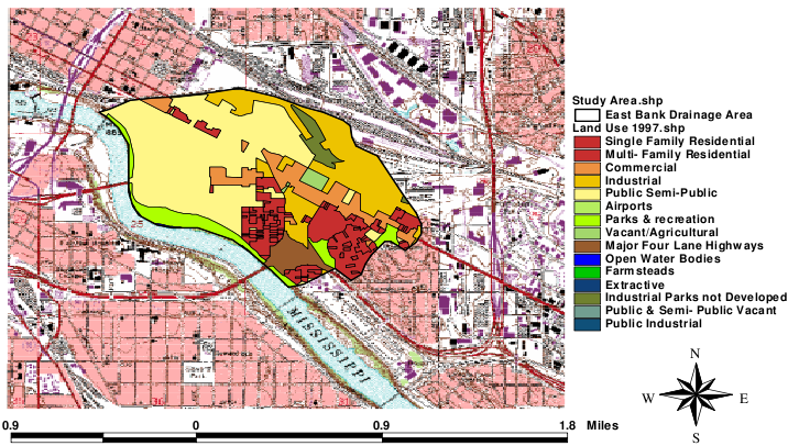 | |
| Title | East Bank Drainage Areas |
| Source | University of Minnesota - East Bank Campus: Watershed Management Plan |
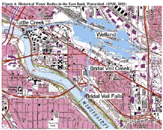 | |
| Title | East Bank Historic Water Bodies [leaves out at least one river from a previous time. Deer Creek, I think.] |
| Source | University of Minnesota - East Bank Campus: Watershed Management Plan |
 | |
| Title | Development of the University of Minnesota |
| Source | University of Minnesota - East Bank Campus: Watershed Management Plan |
 | |
| Source | MNHS - Maps |
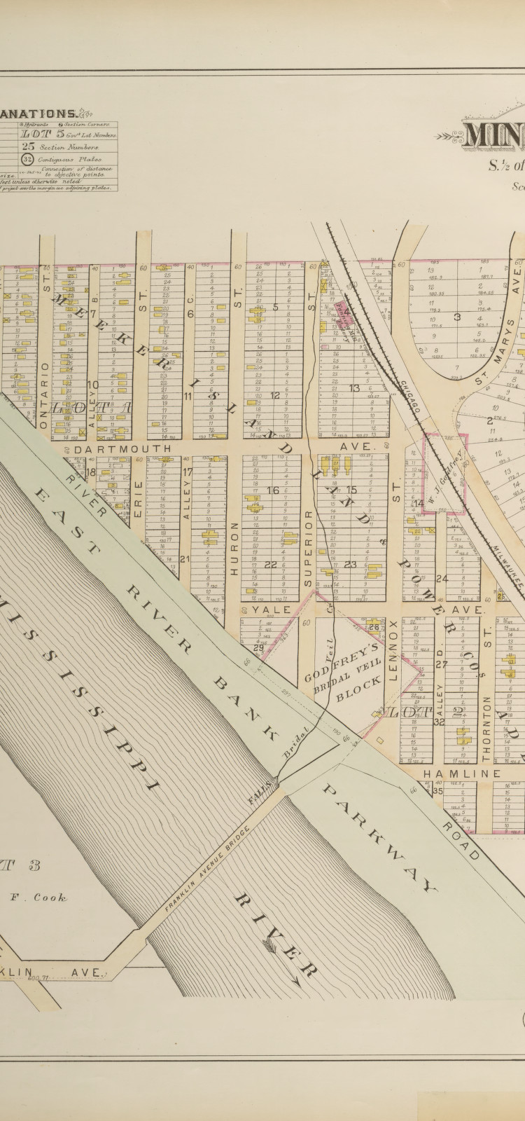
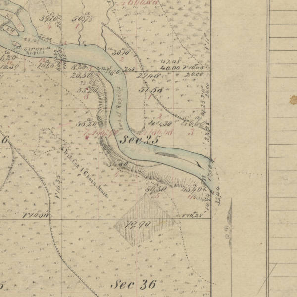
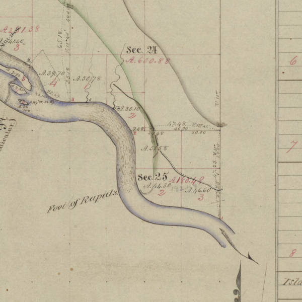
| Title | Survey map of t029r24w |
| Creator | United States. Saint Paul (Minn.) Land Office. |
| Description | Original land survey map of t029r24w |
| Date | 1876 |
| General Subject | Environment |
| Specific Subject | Physical geography -- Minnesota -- Hennepin -- maps. |
| Local Subject | Original survey maps; General Land Office (GLO) maps; plat maps; public land survey; cultural features |
| Minnesota County | Hennepin |
| State | Minnesota |
| Country | United States |
| Parent Collection | Original Land Survey Maps of Minnesota Collection |
| Contributing Institution | Minnesota Historical Society; Minnesota Office of the Secretary of State; Land Management Information Center; Minnesota Department of Transportation |
| Rights Management | These images have NOT been certified by the Minnesota Office of the Secretary of State as exact, digital copies of the original source documents. These images are NOT geo-referenced.The Land Management Information Center makes no representation or warranties, express or implied, with respect to the reuse of data provided herewith, regardless of its format or the means of its transmission. There is no guarantee or representation to the user as to the accuracy, currency, suitability, or reliability of this data for any purpose. The user accepts the data 'as is', and assumes all risks associated with its use. By accepting this data, the user agrees not to transmit this data or provide access to it or any part of it to another party unless the user shall include with the data a copy of this disclaimer. The Land Management Information Center assumes no responsibility for actual or consequential damage incurred as a result of any user's reliance on this data. |
| Local Identifier | MHS0898 |
| MDL Identifier | t029r24w4fc01.tif |
| Township | 29 |
| Range | 24 |
| Township/Range | t029r24w |
| Litoral | w |
| Principal Meridian | 4 |
| Fractional Township | n |
| Fractional Range | n |
| Plat Type | Completion |
| Plat Material | Linen |
 | |
| Source | MNHS - Maps |
| Title | Survey map of t029r24w |
| Creator | United States. Dubuque (Iowa) Land Office. |
| Description | Original land survey map of t029r24w |
| Date | 1856 |
| General Subject | Environment |
| Specific Subject | Physical geography -- Minnesota -- Hennepin -- maps. |
| Local Subject | Original survey maps; General Land Office (GLO) maps; plat maps; public land survey; cultural features |
| Minnesota County | Hennepin |
| State | Minnesota |
| Country | United States |
| Parent Collection | Original Land Survey Maps of Minnesota Collection |
| Contributing Institution | Minnesota Historical Society; Minnesota Office of the Secretary of State; Land Management Information Center; Minnesota Department of Transportation |
| Rights Management | These images have NOT been certified by the Minnesota Office of the Secretary of State as exact, digital copies of the original source documents. These images are NOT geo-referenced.The Land Management Information Center makes no representation or warranties, express or implied, with respect to the reuse of data provided herewith, regardless of its format or the means of its transmission. There is no guarantee or representation to the user as to the accuracy, currency, suitability, or reliability of this data for any purpose. The user accepts the data 'as is', and assumes all risks associated with its use. By accepting this data, the user agrees not to transmit this data or provide access to it or any part of it to another party unless the user shall include with the data a copy of this disclaimer. The Land Management Information Center assumes no responsibility for actual or consequential damage incurred as a result of any user's reliance on this data. |
| Local Identifier | MHS0900 |
| MDL Identifier | t029r24w4fi04.tif |
| Township | 29 |
| Range | 24 |
| Township/Range | t029r24w |
| Litoral | w |
| Principal Meridian | 4 |
| Fractional Township | n |
| Fractional Range | n |
| Plat Type | Independent |
| Plat Material | Paper |
| |
| Source | MNHS - Maps |
| Title | Map of Hennepin County, Minnesota |
| Creator | Wright, George Burdick, 1835-1882 |
| Contributor | Rice, G. Jay; St. Paul Lithographic & Engraving Co. (Saint Paul, Minn.) |
| Description | 1 atlas (39 [i.e.41] p.), hand colored maps 28 x 34 cm. Include George B. Wright's map of Minneapolis, 1873, at back (32 x 34 cm). |
| Date | 1873 |
| General Subject | Environment |
| Specific Subject | Maps |
| Local Subject | Real property -- Minnesota -- Hennepin County -- Maps -- 1873. Hennepin County (Minn.) -- Maps -- 1873. Minneapolis (Minn.) -- Maps -- 1873. |
| Minnesota County | Hennepin |
| State | Minnesota |
| Country | United States |
| Contributing Institution | Minnesota Historical Society, 345 Kellogg Boulevard West, St. Paul, MN 55102 |
| Rights Management | http://www.mnhs.org/mhsuse.html |
| Local Identifier | G1428.H4 W74 1873 |
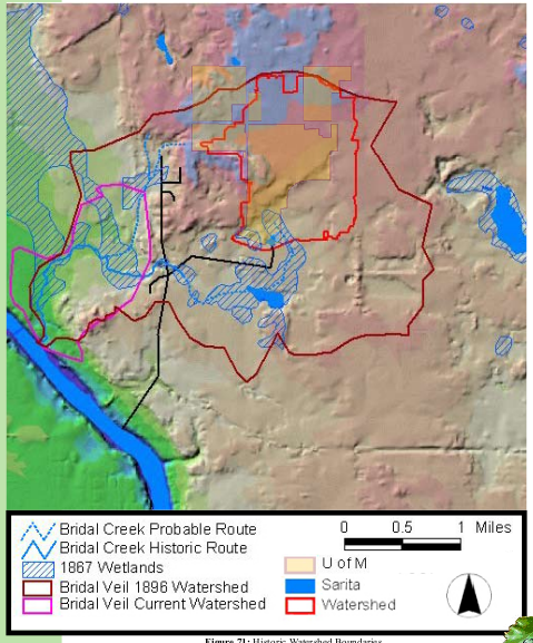 | |
| Title | Historic Watershed Boundaries |
| Source | St. Paul Campus Ecological Master Plan Site Analysis |